FER - Surveying#
Contributors
The annotated PPI surveying and earthwork notes and the annotated CONE 2302 notes were prepared by Mr. David Spears, P.E.
Readings#
Videos#
Angles, Distances, and Trigonometry#
Note
Narrative and equations go here.
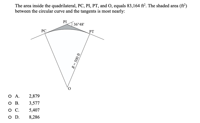
Example 1:#
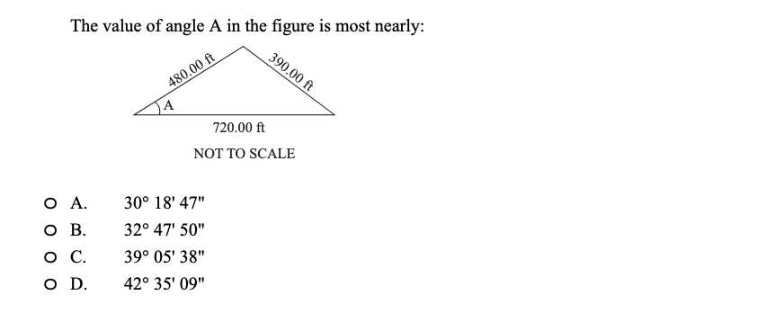
Example 2:#
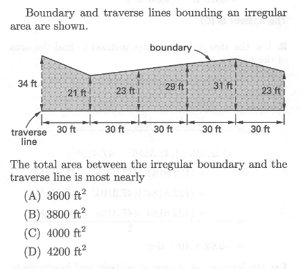
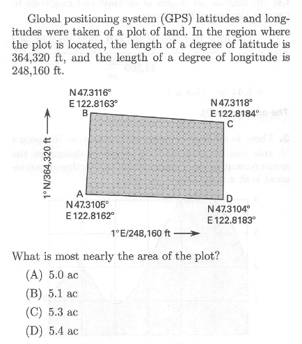
Area Computations#
Note
Coordinate systems matter. UTM is nearly cartesian and can use Homer Simpson’s rule for plane areas.
Convert DMS into cartesian before making area calculations or use great circle projections then convert DMS\(^2\) into plane areas.
Earthwork and Volume Computations#
Note
Narrative and equations go here.
Example 3:#
Coordinate Systems#
Note
Narrative and equations go here.
Leveling#
Note
Narrative and equations go here.
Backsight/Foresight(s)#
In surveying, a backsight (BS) is a reading taken to a point of known elevation, typically a benchmark, to help establish or verify the height of the surveying instrument (like a level or theodolite) before measuring points of unknown elevation. It is a “backward” sight along the line of progress and is essential for calculating the height of instrument (HI) and determining the elevation of subsequent points in the survey.
Purpose of a Backsight
Establish Instrument Height: When a surveying instrument is set up in a new location, a backsight on a point with a known elevation (like a benchmark) is used to calculate the instrument’s height.
Maintain Level Circuits: In leveling surveys, backsights are taken on a known point to keep a continuous record of elevation changes as the instrument is moved.
Verify Elevations: Backsights are also used to check the accuracy of the survey by ensuring the calculated elevation of the instrument matches the expected elevation of the point.
How it Works
Set up the instrument: The surveying instrument is positioned on a stable surface.
Take the backsight: A leveling rod is held vertically at a point with a known reduced level (RL), and the surveyor takes a reading with the instrument.
Calculate the height of instrument (HI): The backsight reading is added to the known RL of the benchmark to find the HI. For example, if a benchmark is at 98 meters and the backsight reading is 3 meters, the HI is 101 meters.
Take foresights: From this established HI, foresights (FS) are then taken on points where the elevation needs to be determined.
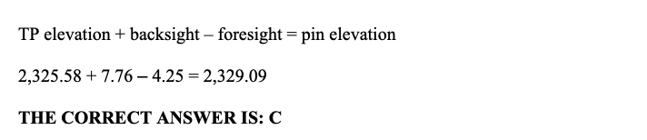
Example 5#
Section End#
Surveying Quiz Preview Placeholder no active link