FER - Hydrology (Runoff and Seepage)#
Contributors
This webpage includes materials contributed by Dr. Theodore G. Cleveland, the designated subject-matter expert for this topic. Additional sources are cited where applicable; all other content was prepared by the JupyterBook’s author.
Readings#
Videos#
Civil FE/PE Exam – Hydraulics & Hydrology – Best Drainage Analysis Method for Pond Storage
FE Exam Concepts - Darcy’s Law - Groundwater Flow - Civil & Environmental FE
Hydrology Topic 2-3-5 Precipitation Data Analysis / Point Precipitation / Mean Areal Rainfall
Hydrology, Hydraulics, and Groundwater Quiz with Explained Solutions (Cleveland)
Problem 59 (NCEES Practice Exam Manual)#
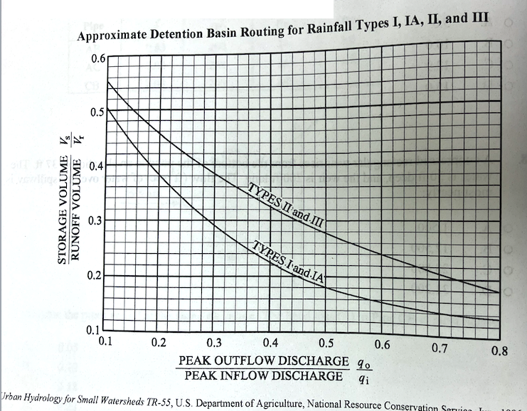
For a new development of 75 acres (0.117 \(~mi^2\)), the peak runoff for a 25-year storm of 360 cfs is to be limited to 180 cfs by use of a detention basin. The total runoff \(Q\) is 3.4 inches. Assume Type II rainfall. Using the TR55 Method and the figure below, the preliminary estimate of storage volume (ac-ft) is most nearly:
A. 0.07
B. 0.11
C. 3.80
D. 5.94
# solution - find total runoff in acre feet
Q=3.4 #in
A=75.0 #acres
volRunoff=Q*(1/12)*A
# use required peak discharge ratio 180/360 to find storage to runoff ratio from chart
qratio = 180/360
# look up storage to runoff ratio in chart
print("Discharge Ratio : ",qratio)
Discharge Ratio : 0.5
look up storage to runoff ratio in chart
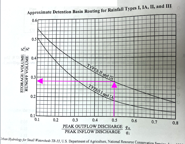
stor2runoff = 0.28
# compute required storage
basinStorage = stor2runoff*volRunoff
print("Runoff Volume : ",volRunoff," acre-ft ")
print("Discharge Ratio : ",qratio)
print("Storage to Runoff Ratio : ",stor2runoff)
print("Basin Storage Required : ",basinStorage," acre-ft ")
Runoff Volume :  21.25  acre-ft
Discharge Ratio :  0.5
Storage to Runoff Ratio :  0.28
Basin Storage Required :  5.95  acre-ft
Computed answer is 5.92 acre-ft, choose “D”
Problem 61 (NCEES Practice Exam Manual)#
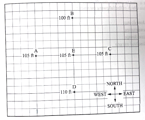
Four monitoring wells - A,B,C,and D - lie equidistant (200~ft) form a fifth well E. The depth to the water table is measured at each well and is shown below. The datum for the top of casing (TOC) for each well is equal to the five wells. Groundwater moves in which direction from point E?
(A) South
(B) East
(C) North
(D) West
# solution - the values given are depth to water (DTW) so we subtract from TOC to get head
toc = 500 # any number would be fine
dtwA = 105
dtwB = 100
dtwC = 105
dtwD = 110
dtwE = 105
hA = toc-dtwA
hB = toc-dtwB
hC = toc-dtwC
hD = toc-dtwD
hE = toc-dtwE
print("head A : ",hA)
print("head B : ",hB)
print("head C : ",hC)
print("head D : ",hD)
print("head E : ",hE)
head A :  395
head B :  400
head C :  395
head D :  390
head E :  395
now draw equipotentials, and find flowline
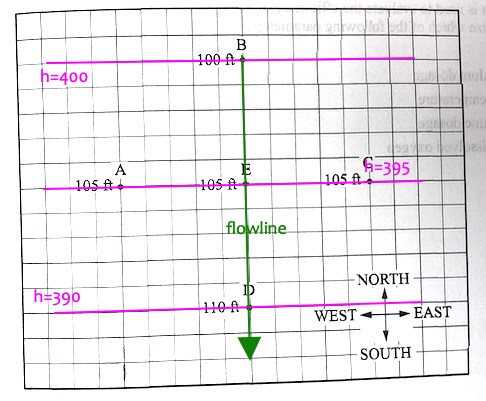
Best answer is A (South)
Problem#
A 3.2-inch storm is uniformly distributed over a 95 acre watershed. The NRCS Curve Number for the watershed is CN = 78. The anticipated watershed runoff is about
(A) 8.0 acre-feet
(B) 9.0 acre-feet
(C) 10.0 acre-feet
(D) 11.0 acre-feet
CN = 78
P = 3.2
A = 95
S = 1000/CN - 10
Q = ((P-0.2*S)**2)/(P+0.8*S)
print("Runoff in watershed inches",Q)
acre_feet = (Q/12)*A
print("Runoff in acre-feet",acre_feet)
Runoff in watershed inches 1.2733564680933103
Runoff in acre-feet 10.080738705738707